Introduction
At ONEGEO, we're constantly pushing boundaries. Building height has always been a pivotal aspect of geospatial data. Today, we're thrilled to introduce the refined 'Global Heights 2.0' feature, a testament to our commitment to accuracy and innovation. Dive in as we explore the enhancements and the value they bring to your geospatial endeavors.
The Evolution of the 'Global Heights' Feature
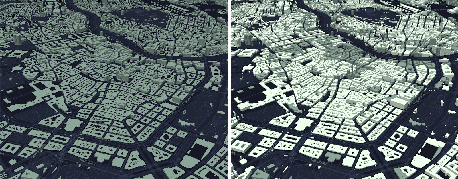
In the realm of geospatial analysis, the demand for precise building height stands out. The West leads in data quality, but achieving global consistency remains a challenge. Our initial coverage touched 90 million buildings, just 14% of our database. Recognizing the need for enhancement, especially in urban areas, we've been working hard behind the scenes and have just released 'Global Heights 2.0' - now bringing you comprehensive coverage regardless of location.
What's New in Global Heights 2.0?
'Global Heights' transforms flat geometries into 3D using advanced algorithms to infer the likely building heights based on known values and attributes. With a refined 5m global grid, we've also significantly enhanced the resolution, ensuring that every building is represented with greater accuracy.
Moreover, the intricacies of urban landscapes and a more nuanced understanding of structures now factor into the result.
Building Types
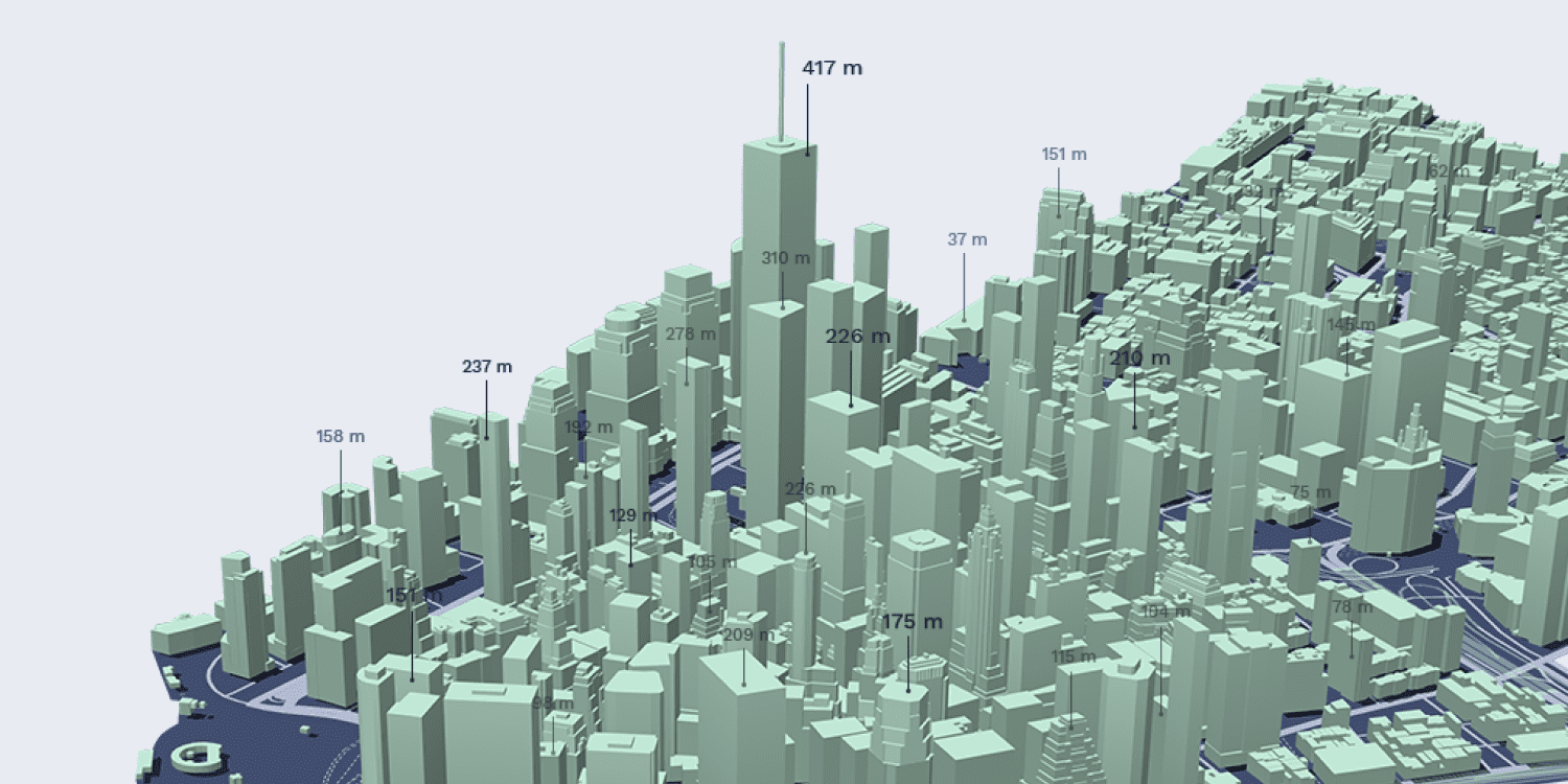
A good example is a church that commonly lies at the heart of many European towns and villages. A church is generally much higher than the surrounding buildings, which would have previously impacted the inferred height of nearby buildings. Now, the 'building type' attribute identifying a building as a church will trigger it to not affect nearby buildings.
Building Density
Building density now also factors into Global Heights, as denser downtown areas, such as the CBD of larger cities, generally have higher building heights than residential areas in the outer suburbs.
Building Footprint
We considered the utility of including the building footprint as a factor but our analysis proved it to be more random than revelatory and thus it does not factor into the Global Heights.
Data Sources and Updates
Our worldwide 3D buildings database includes both buildings with measured heights and those with heights based on the 'Global Heights 2.0' analytical AI feature. Our database is based on a rich combination of over 40 data sources, ensuring the best possible coverage and attribute density. It is updated monthly to reflect changes and provide you with an up-to-date picture of the built environment.
Accuracy of Global Heights 2.0
The accuracy of the 'Global Heights', generated by a combination of analytical approaches and AI, depends on the quality of the input data the algorithms have to work with within a certain area, and thus varies across the globe.
At this point, it is important to mention that while 'Global Heights' is a cost-effective approach, we acknowledge its estimative nature. It's this very estimation, rooted in data and analytics, that provides a vivid impression of cityscapes that's nonetheless economical.
However, for those seeking 100% accurate building height data for all buildings within their AOI, a high-precision dataset will likely be required at a much greater cost - an option that we offer upon request. A use case requiring 100% accuracy could be flight path routing, for example.

If you're not sure whether the accuracy is sufficient for your project, here are a few things you can consider to help you decide:
Percentage of Measured vs. AI Height Data
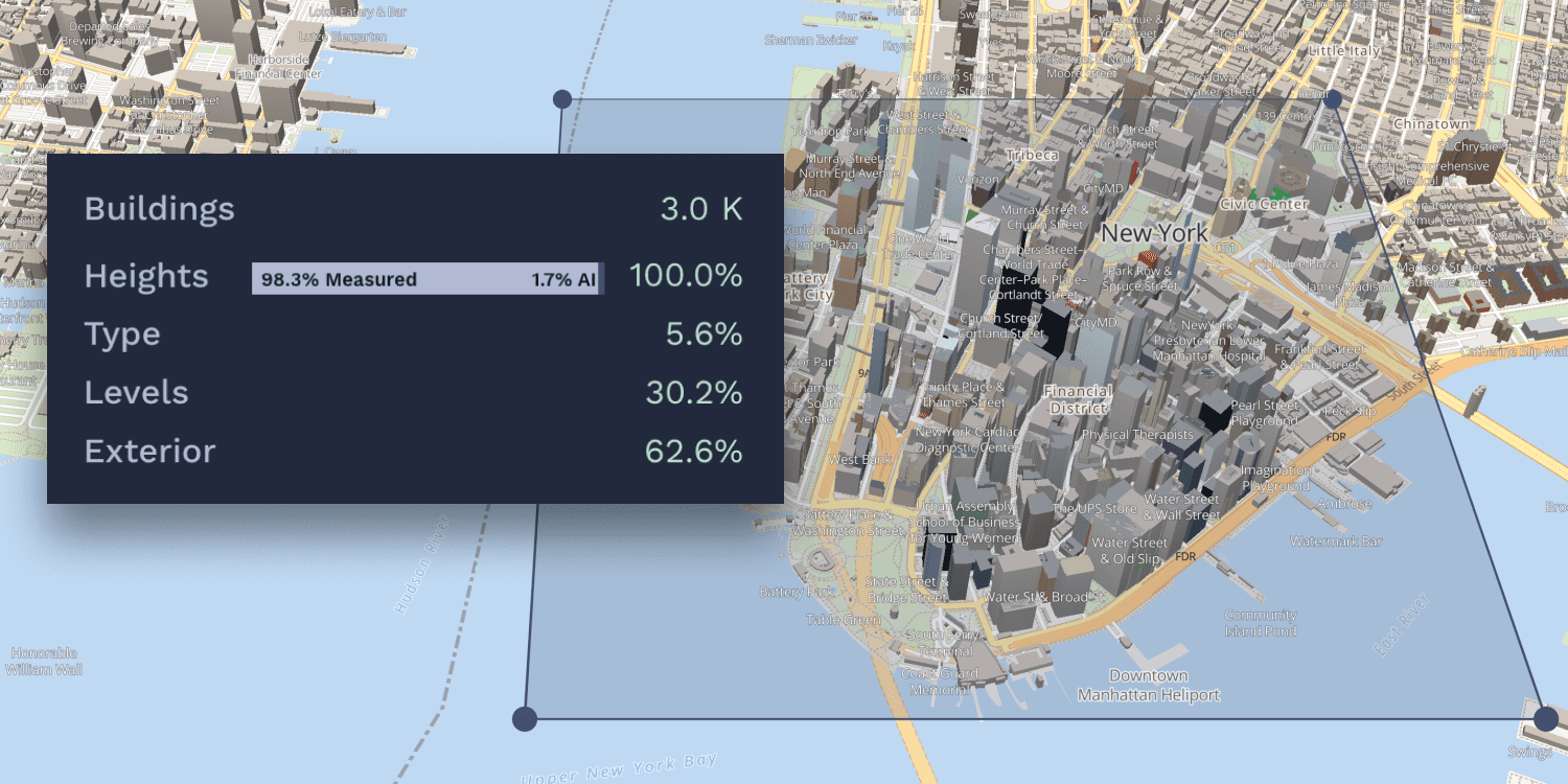
When looking at our map, you will see that for every area you select, the percentage of measured and AI-inferred building heights is given. This varies drastically across the globe, with 98.3% measured heights in downtown New York City, for example, and only 32.1% for downtown Montreal.
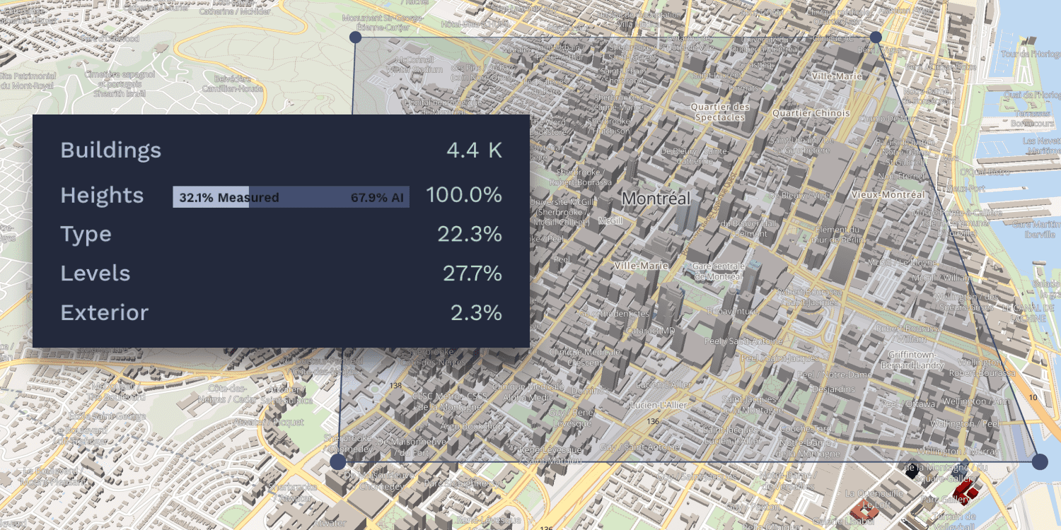
So check out your area of interest to see what percentage is measured height data. The more measured data the algorithms have to work with, the higher the accuracy of the inferred heights, so if your area of interest has between 30% and 50% measured heights, you're looking at a decent level of accuracy of the inferred heights too.
Height Data Source Attribute
Each building in our database has the attribute 'heightSrc' so you can filter by 'measured' and 'AI-inferred' building heights to see which buildings have measured and which have inferred heights. This is particularly useful if you're interested in one particular building but would like to show the surroundings to give an impression.
A use case example of this could be real estate, where the focus is on a particular building, but you would like to show it in its urban context. It also means that you can 'turn off' the inferred heights and work only with the measured heights - this could be useful if your buildings of interest have measured heights and you're not interested in the surrounding buildings.
Project Requirements and Budget
Ultimately, your project requirements and budget will determine the level of accuracy you need to achieve. If 100% accuracy is indispensable, you will likely need data collected specifically for your area of interest.
If your budget doesn't allow for such an expense, consider getting a free $50 coupon for our data and testing it for your area of interest to determine whether the accuracy is sufficient for your project - remember, you can see the height source of each individual building in the attributes and be sure to look at the percentage of measured and inferred height data as well.

Looking Ahead: We're Constantly Improving Precision
Innovation at ONEGEO is a continuous journey, not a destination. While we celebrate the advancements of our updated 'Global Heights 2.0', we're already envisioning its next evolution.
While we're already able to provide very high accuracy in certain parts of the world - especially the USA and Europe, we are striving to improve the accuracy worldwide. This will be achieved as we obtain more and more measured heights and improve our algorithms to be even more attuned to the intricacies of urban landscapes around the world.
The ONEGEO database is updated monthly, and new data sources are constantly being integrated. We're working tirelessly to bring you the best 3D building data available without having to charge premium prices for custom-collected data.
For those requiring custom-collected data, we offer this option upon request. To make it as economical as possible for you, you could consider getting your core area of interest custom-collected while relying on our comprehensive database to supplement your project where 100% accuracy is not a necessity. We have your best interest in mind, so please don't hesitate to contact us if you have specific requirements that we may be able to help you with.
Ready to get started?
Get your $50 coupon and start exploring.