Power Your Project with the Right Building Data
Select from more than many buildings in our database and download them right now in 2D or 3D.


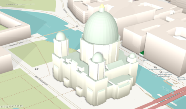
Unlock New Dimensions with the ONEGEO 3D Model
Leverage a detailed 3D building model, complete with texture- and colour information, rendered as individually selectable buildings on a comprehensive terrain model.
Catering to a broad range of industries and use-cases, our 3D building model provides an immersive experience and accurate visual simulations to enhance understanding of your data and user engagement.
Here's what you get
Save Time and Resources
No more searching for the right data and converting between formats. With us, you'll always have the data you need, when you need it.
Effortless Integration
Say goodbye to the hassle of finding, downloading, and converting data. We provide 3D building data in a GIS-ready format or accessible through API.
Data-driven Decisions
Transform your decision-making with valuable insights derived from our comprehensive coverage of the built environment.
Impactful Visualizations
Impress your audience with stunning visual representations of the built environment, made easy with our accurate and accessible 3D building data.
Reliable Data with Regular Updates
Our robust data is less prone to errors, outliers, or missing information because we quality check all our data and update it monthly.
Maximize Your Efficiency
Save time and resources by relying on our cost-effective solution, so you can focus on what really matters.
Whatever you're working on, take it to the next level with the right building data
From spatial analysis and planning, to research, to business insights, our data powers projects around the world
3D Models
Create high quality, attribute-rich building layers for next-gen 3D maps and digital twins.
Analysis
More insights = better outcomes, so get the most out of your data with geospatial analysis.
Maps
Show rather than tell by building your own unique, powerful, and instantly-identifiable maps.
40 data sources
and counting
With our unique combination of over 40 data sources, carefully curated and updated monthly, we provide you with a comprehensive and up-to-date picture of the built environment for your project.
Our datasets draw on OpenStreetMap data as well as additional sources that are independent of and not affiliated with OpenStreetMap to provide you with reliable and accurate results.
List of data sources
Developer documentation

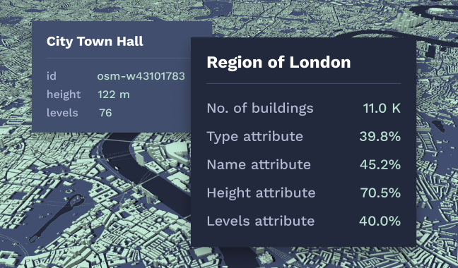
The Value
of Building Heights
To give you a more robust asset, we've added height information to every building in our database.
Building height information is crucial, not only for 3D visualization, but also for geospatial analysis.
It also allows you to generate information such as line of sight and wireless signal propagation.
Global Heights combines different analytical approaches and machine learning to effectively classify built-up areas.